Total Pageviews

Tuesday 28 August 2012

Walk 76 Holy Island to Berwick-upon-Tweed


Walk 76          The coast opposite Holy Island to Berwick-upon-Tweed (Northumberland)

(First leg of English coastal walk – Broadstairs in Kent to Berwick at the border with Scotland).

Map: L/R 75
Distance: 10 miles or 15 km approx
Difficulty:  Fairly easy
Terrain: footpaths, sand and pavement
Access: Parking at Berwick (There is some parking near where the Causeway starts for Holy Island).
Public transport: 501/505 link to Berwick - times vary according to tides at Lindisfarne.

Walk through Beal to the Northumberland Coast Path. The vast stretches of Goswick then Cheswick Sands are alongside the sand dunes. Don’t be tempted to walk out towards the sea as there are dangerous quick-sands and when the tide turns it races in and there is a risk of being cut off.  

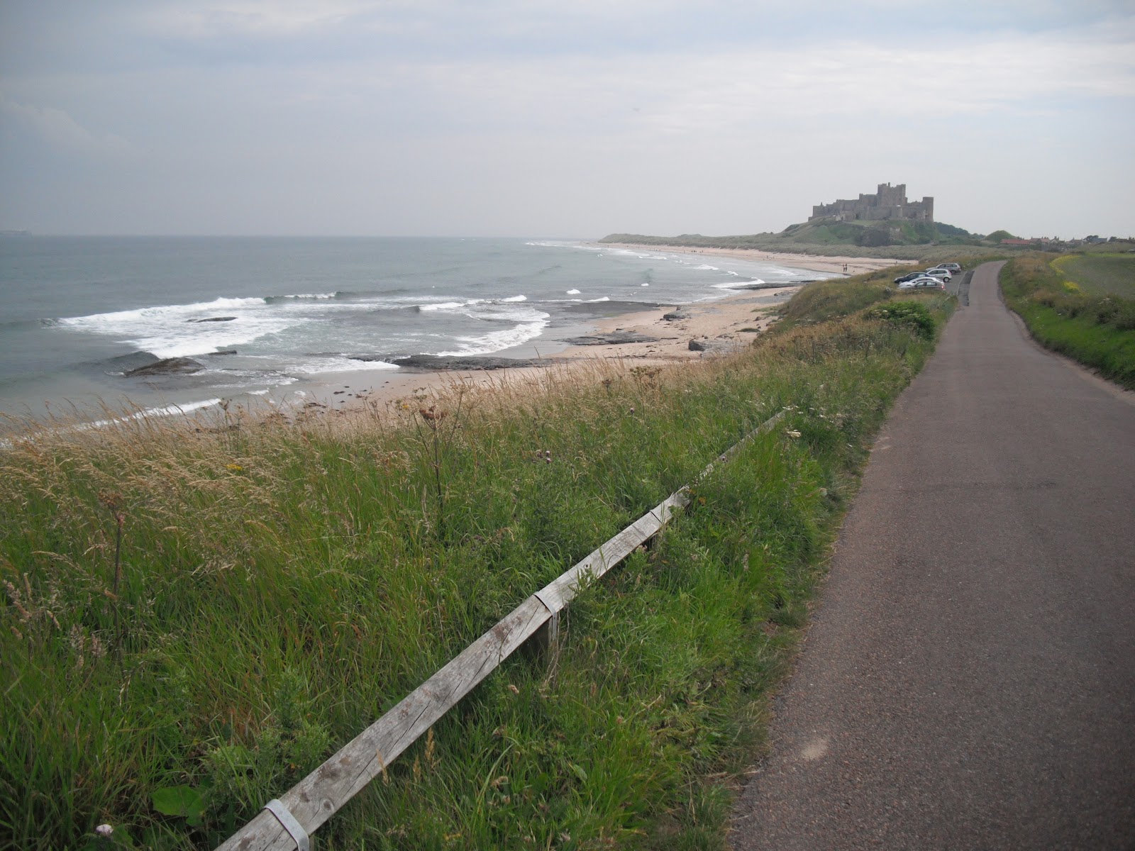
Much of the walk north meanders alongside a golf course. Parts were flooded when I went and were just about passable.  For a small stretch the path runs parallel 
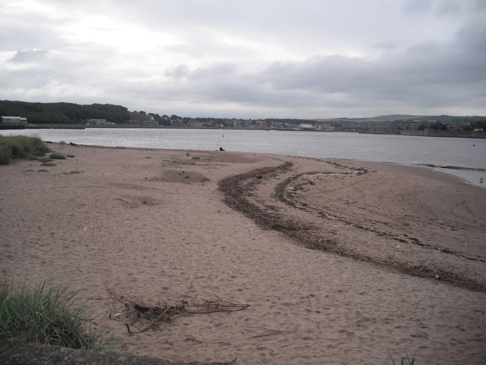
with the main east coast rail line. I took my own route down to the coast so I could see Spittal Sands. The official coast path follows the road into Berwick.

Spittal is a former fishing village – its name derives from a leper hospital which stood here in the middle ages. L S Lowry, the famous painter, was active in painting scenes in and around Berwick. The sands at Spittal were one of his subjects. Information boards here and in Berwick provide lots of background detail. Until the 1950s a little ferry crossed the estuary to Berwick and Lowry painted this and other sailing boats.

With its long sandy beach and spa, Spittal became a popular holiday resort in the 19th century. There is an old chimney near the beach but I could not find out what it was used for.

Cut along the estuary to England’s most northerly town. Between 1147 and 1482 Berwick changed hands between the Scots and English thirteen times. The slightly ambiguous nature of the town is reflected in the status of its football team. Berwick Rangers are firmly in England but play in the Scottish league.

The town is particularly attractive, especially the old bridge which dates back to the 17th century. It was built after James 1st is said to have complained about the dodgy wooden one that he was forced to use. It is now used one way for traffic and for pedestrians; this is the one you should use to cross into the main town. Further along the river is The Royal Tweed Bridge which was opened in 1920 and takes most of the heavy traffic. Also down this end is the impressive railway viaduct.

Pictures show: Goswick Sands; estuary near Spittal; the old bridge at Berwick; looking along the old bridge to the town.


Sunday 19 August 2012

Walk 75 Holy Island (Lindisfarne)


Walk 75          Holy Island  (Lindisfarne) 

(First leg of English coastal walk – Broadstairs in Kent to Berwick at the border with Scotland).

Map: L/R 75
Distance: about 20 km or 13 miles unless driving on to the island in which case probably 4 miles max
Difficulty:  Fairly easy
Terrain: footpaths and pavement
Access: Parking on the island
Public transport: Bus 501,505 stopping near Beal on the main road.

THIS WALK NEEDS TO BE PLANNED CAREFULLY IN ADVANCE OTHERWISE YOU COULD BE STRANDED ON THE ISLAND OR WORSE FIND YOURSELF STUCK IN DEEP WATER IN A VEHICLE OR ON FOOT. CHECK THE SAFE TIMES TO CROSS TO THE ISLAND AND GET OFF AGAIN. BUSES VARY DEPENDING ON THESE TIMES.


Walk the couple of miles from the main road through Beal and on to the start of the Causeway to Holy Island. You will see many notices warning of tide dangers; despite these many cars get stranded every year and suffer terminal damage. I don’t suppose the coastguard people are very amused either! Half way across is a refuge – you don’t want to be using this. The views to the mainland are very attractive and well worth several stops to gaze back.  


The path follows the road and crosses a nature reserve. Continue on this path jointly known as St Cuthbert’s and St Oswald’s Way until the main village. It is well worth a visit to the heritage centre to learn about the history of the island which, together with Canterbury in Kent, is recognised as the cradle of Christianity in England. No visit is complete without a visit to the atmospheric priory of St Aidan. Although a ruin, there is enough left to appreciate the construction of the building and there is helpful information around identifying the various parts.


St Aidan established the priory in the 7th century but virtually nothing remains of this building which was destroyed by Viking invaders. Benedictine monks formed a new monastery here two centuries later and the Norman Priory now stands on the same site. Aidan is originally believed to have chosen this location because of its isolation and proximity to the Northumbrian capital at Bamburgh. It was therefore a good place to launch his conversion of the area to Christianity. In the mid 7th century Cuthbert became the fifth bishop and further built on the island’s reputation with his ability to heal the sick and work miracles. The monastery was used until the suppression of the monasteries by Henry V111 in 1537.


Try to  visit Durham when in the area (the cathedral there is the most magnificent one I have seen) there is an impressive statue in a shopping area showing the monks of Lindisfarne taking the body of St Cuthbert to ‘found’ Durham Cathedral – his tomb is to be found in the crypt.


Bcak to the island, take a walk to Lindisfarne Castle which is clearly visible from the priory (or if you are feeling lazy take the 'shuttle' bus). The Castle was built in the mid 16th century to defend the island from the Scots and then as a fort from 1559 until 1893. Sir Edwin Luytens, the famous architect turned the castle into a holiday home early in the twentieth century. The National Trust now own it and it is worth a visit.


Look out for the upturned boats around the castle which now serve as storage sheds. From near this point you can see some lime kilns. These were built in 1860 and were in use until 1900. Limestone was quarried on the island and was mainly used as a fertiliser. A walk to the nearby peaceful Gertrude Jekyll garden is worthwhile on a pleasant day.


The walk finishes with a stroll northwards across the links to appreciate the more remote areas of the island. Backtrack to the car park or back on to the main road past Beal.


Photos show: monk sculpture in Durham; two views of the Holy Island monastery/priory; upturned boat sheds near Lindisfarne Castle. 


Monday 6 August 2012

Walk 74 Seahouses to Belford (Northumberland)


Walk 74          Seahouses to Belford (Northumberland)

(First leg of English coastal walk – Broadstairs in Kent to Berwick at the border with Scotland).

Map: L/R 75
Distance: about 10 miles or 16 km
Difficulty:  Mainly easy
Terrain: footpaths, pavement, cliff paths, sand
Access: Parking at both ends
Public transport: Bus 401, 411 from Alnwick to Craster, 501/505 Berwick/Alnwick/Belford Seahouses – check with Traveline.

The first part of the walk out of Seahouses is along the road. There is then a choice to continue along the road or to take a much more pleasant route along the beach to Bamburgh. This is possible when the tide does not come right up to the foreshore so it is worth checking the tide times first.

The Farne Islands can be spotted 2/3 miles offshore. It has the most famous bird sanctuary in the British Isles and has a large colony of grey seals. There are 28 islands of which 15 are visible at high tide. The islands are associated with St Aidan and St Cuthbert who used to stay here and meditate. Farne is also famous for the heroics of Grace Darling. She made headlines in 1838 when, at the age of 23, she helped her father (who was a lighthouse keeper on the islands) row out and rescue a number of men from the stricken steamer Forfarshire. Sadly she died from TB aged just 26. The lighthouse can be visited by boat and there are specialist trips to observe the wildlife. A museum in nearby Bamburgh is devoted to Grace Darling and provides interesting background to her story.

Bamburgh Castle is a significant landmark along this shore. There was a castle here originally built by King Ida of Northumberland but the present building was begun by Henry 1st. It has played its part in the tussles between England and Scotland and The Wars of the Roses. The walls of the castle form a 150 foot precipice. Most of the visible parts of the building were completed in the 18th and 19th centuries when it was used as a boarding school to train servant girls. In 1971 it was chosen as Macbeth’s stronghold in the film version of the play by Roman Polanski. The castle is now in private hands and is open to the public – well worth a visit.

The walk to Budle Bay can be a bit confusing at times as you are never quite sure whether you are on the path or the golf course. A lighthouse is nestled on Harkess Rocks.   

Follow St Oswald’s Way into Belford. This path links some of the places associated with St Oswald, King of Northumbria in the 7th century. He played a major part in bringing Christianity to the area.

The walk finishes at the old village of Belford.

Pictures show: beach walk between Seahouses and Bamburgh; looking south to Bamburgh Castle; Bamburgh village and castle; lighthouse at Harkess Rocks.