Total Pageviews

Tuesday 22 December 2015

Walk 154 Lands End to St Just (Cornwall)

Walk 154 Lands End to St Just (Cornwall)

(Third leg of English coastal walk – Lands End to Bristol)

Map: L/R 203
Distance: 9 miles or 13 km approx.
Difficulty: Demanding with some easier parts
Terrain: cliff coastal path with some road walking
Access: Parking at both ends.
Public transport: Buses from Penzance to Lands End and every hour from St Just to Penzance.

Start by exploring the buildings and features around Lands End. These include Penwith House which was once a temperance hotel and is now a gift shop. The famous sign, where you can have one finger-post pointing to your own town and the distance to it, appears to be under the control of an official photographer. The First and Last Refreshment House is situated on the most south westerly point of England. In Arthurian legend this spot is the halfway point between Lands End and the Isles of Scilly and is where the mythical land of Lyonesse was supposedly swallowed by the ocean.

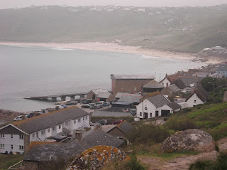
The fist headland along the coastal path from Lands End is Dr Syntax's Head. It is thought that this may have been named after a 19th century local school master and that the shape was like his chin! At Pedn-men-du is a 19th century coastguard look out built on the craggy rocks. The path drops down a road and then into Sennen Cove which is at the southern end of Whitesand Bay. It is very popular with surfers. It was also home to the first canine lifeguard in the UK, a dog called Bilbo. He was active between 2005-2007 and there have been petitions to bring him back. I noticed a member of the RNLI checking on the safety of surfers on his quadbike. One of the more popular duties I would think.

On the walk to Cape Cornwall there are several warnings of exposed old tin mine shafts. It is strongly advised that you keep to the path unless you want to risk disappearing without trace. The cape (the only one so named in England) is the second most westerly point in the UK and is capped by an old mining tower. The area is owned by the National Trust so all of the cape can be explored. Out at sea, on the south side, are The Brisons. In 1851, the ship,The New Commercial, ended up on these rocks but the captain and his wife remained on board until the crew were rescued. They were both pulled off but, unfortunately, the wife died before reaching the shore.

Follow the walk around past a few old tin mine chimneys then take one of the roads or paths into St Just.

Photos show: Sennen Cove and Whitesand Bay; Cape Cornwall.


Saturday 19 December 2015

Walk 153 Porthcurno to Lands End (Cornwall)

Walk 153 Porthcurno to Lands End (Cornwall)

(Second leg of English coastal walk – Broadstairs to Lands End)

Map: L/R 203
Distance: 6 miles or 10 km approx.
Difficulty: Moderate, overall
Terrain: cliff coastal path
Access: Parking at both ends.
Public transport: Bus 1A runs from Penzance to Porthcurno a few times a day, more regular services from Lands End – check with Traveline as they depend on the season.

After a short walk from Porthcurno you arrive at the unique Minnack Open Air Theatre. It is well worth allowing time here to look around. It owes its existence to a Miss Cade who allowed a group of local actors the chance to perform The Tempest on the rocks adjacent to her home, Minnack Cottage. The first performances in 1932 were on a grassy slope with lighting provided by car headlights, batteries and power brought down from the cottage. It has developed from this time into a fully equipped national theatre with a number of well known actors performing with the sea as a backdrop. Every ten years there is a commemorative performance of The Tempest. A superb sight on a sunny day. If you want to see a live performance book early as it is very popular.

The next feature is the picturesque Porth Chapel, then a bit further along is Porthgwarra. The beach here can be accessed by an attractive narrow archway in the cliff. This was a tunnel dug by tin miners to give farmers horse and cart access to the beach to collect seaweed which was used as fertiliser. The beach is privately owned but members of the public are allowed to enjoy it quietly.

About half a mile along the path is Gwennap Head with its coastguard lookout. In an area close to the path is a very deep hole – not sure whether this was the result of mining or if it is natural. The Chair Ladder along the cliffs is a famous challenge for climbers and has been used by the army for training.

The bright blue of the sea especially around Folly Cove is stunning. The approach to Lands End is distinguished by the jagged granite rocks. A little out to sea is the Longships Lighthouse. It takes its name from the rocks that it sits upon which are said to resemble Viking longships.

The coastal path cuts inland at Lands End and goes past Greeb Farm which is 200 years old. Small animals, various craft workers and a resident artist can be visited.

The entrance to Land End is via the Lands End Experience. I have heard this called 'tacky commercialisation' but leave this judgement to others. Interactive shows, shopping, restaurants and bars are among the attractions.

More about Lands End on the next walk which starts here.

Photos show: The blue sea at Folly Cove; The Minnack open air theatre.


Tuesday 15 December 2015

Walk 152 Newlyn to Porthcurno (Cornwall)

Walk 152 Newlyn to Porthcurno (Cornwall)

(Second leg of English coastal walk – Broadstairs to Lands End)

Map: L/R 203
Distance: 10 miles or 18km approx
Difficulty: Challenging and demanding in parts
Terrain: road and cliff paths
Access: Parking at both ends.
Public transport: Bus 1A runs without changes a few times a day to and from Penzance. Check with Traveline for times.

Follow the path along the road and on to Mousehole. There is a belief that the village got its name from a cave that resembled a mouse hole.

Mousehole, pronounced 'Mouzl', is one of Cornwall's best known and ancient fishing villages. For many years it was the centre of the pilchard fishing industry. The town was sacked (plundered and destroyed) by the Spanish in 1595. In 1981 the town was hit by disaster when the Penlee lifeboat and its 8 man crew was lost. The town's Christmas lights are turned off each December 19th in remembrance of those who died. Today the village has quaint streets with a number of small art galleries/shops.

Continue walking to Penzer and Keymel Points. Some of the walking on this stretch involves clambering over rocks and other difficult terrain. Much of this area is owned by the Cornwall Wildlife Trust. The granite slopes were once home to conifer trees but these were destroyed in a storm. The conditions now favour plants such as fern and it is has become an important haven for various types of wildlife.

The next landmark is Lamorna Cove, a small sandy beach settlement with an old granite pier which was built for exporting stone quarried from the local cliffs and then used in building lighthouses.

The challenging rocky walk continues along to Tater Du with its low lying white lighthouse. This was the UK's first remote control lighthouse when it was built in 1968 and is operated from Penzance.

Further along, look out for a gate with the notice: “The Derek and Jeannie Tangye Minack Chronicles Nature Reserve. A place for solitude.” This couple gave up their jobs to run a flower farm near here and wrote 19 autobiographical books about their life on the farm. In their will they stated that their land must remain as a nature reserve and it is now run by volunteers.

Follow the path around to Penberth Cove and prepare for a walk across large boulder type rocks – ripe for a twisted ankle if you are not careful. Penberth Cove is a picturesque spot with old fishermen's cottages, an old winch and various nets and pots. Phoencian merchants (from middle east area) landed here to buy tin but local miners would not allow them to leave the beach so they could keep their mining methods secret. In past years the fishing industry has declined but there are still a few fishermen who mainly catch mackerel, crab and sea bass.

The walk ends at Porthcurno, look out for the monument to Marconi before arriving at the cove. The beach here is the terminus of ocean cables that connected Britain to international telephone networks. The first link was to Bombay in 1870. To find out more it is well worth visiting The Telegraph Museum inland at Porthcurno – it includes secret World War 2 tunnels and a cable trail to the beach.

Pictures show: the boulders that form a challenging part of the coastal path; Penberth Cove.


Sunday 13 December 2015

Walk 151 St Michael's Mount/Marazion to Penzance and Newlyn (Cornwall)

Walk 151 St Michael's Mount/Marazion to Penzance and Newlyn (Cornwall)

(Second leg of English coastal walk – Broadstairs to Lands End)

Map: L/R 203
Distance: 8 miles or 12 km approx
Difficulty: Fairly easy
Terrain: coastal paths and pavements
Access: Parking at both ends.
Public transport: Plenty of bus links

The walk is mainly alongside the road until Penzance. When I visited there was a heliport near the road where the sky bus regularly flew to the Scilly Isles – I think this is now closed and the service goes from St Just airfield near Lands End. The west coast mainline train service which terminates at Penzance also runs alongside the road.

Follow the walk along to Longrock and the sands, then on to Penzance. The name Penzance comes from 'pen sans' which means 'holy headland' in Cornish. In 1663, Penzance became a coinage town for Cornwall which meant it was responsible for taxes levied on tin mining. The metal was brought down from the smelters by mule and tested for purity. Penlee Museum is well worth a visit for more background information about the area, it also houses an interesting art collection.

Here are a few things to look out for in Penzance:
The Humphrey Davy statue in the centre of the town. Davy was born here in 1778 and at 16 he was appointed as an apprentice to a local doctor. While there he became interested in chemistry and discovered the pain relieving effects of laughing gas. By 24 he became a professor of chemistry and, of course, is best remembered for his work on the miners' safety lamp.
The Egyptian House is marked up on signs, this strange building dates from around 1830 and was restored in the 1970s.
Off the main street is The 17th century Admiral Benbow pub which features in the opening scene of Treasure Island. It has a fascinating collection of maritime artefacts from numerous local wrecks over the last 400 years. Serves good beer and has been visited by many famous people over the years including the Rolling Stones, Gregory Peck and Suggs of Madness.
Not far from here is the Elizabethan Union Hotel, originally a manor house. It was here when there was an attack by the Spanish in 1595. I didn't go in but the blackened walls from the Spanish attack can (reportedly) be seen in The Nelson Bar. Victory in the Battle of Trafalgar was first announced in this building.
The quaint Captain Cutters House which sells specialist tobaccos and is known around the world.

Walking out of the town along the coast there is a stretch of water on the land-side with the Abbey Warehouse in the background. This was built in 1800 as a storage facility for the docks and has recently been restored. There is reputedly a smugglers tunnel to the Admiral Benbow pub.

Further along, adjacent to the harbour, is Ross Bridge. There was a swing bridge here and evidence of the old railway turntable which was used to operate it can still be seen. The Jubilee Park on the coast side was opened in 1935 at the time of George V's jubilee and was built in a streamlined fashion so it could cope with the frequent storms and high winds. It was successfully restored in recent years by a local architect.

The walk continues seamlessly into Newlyn, a traditional harbour with a fishing fleet. The town was home to William Lovett one of the leaders of the Chartist Movement in the 19th century. Members were dedicated to bringing about electoral reform in England. The Newlyn riots took place in 1896 when local fishermen, who strongly supported the Sabbath as a day of rest, took exception to crews from the north of England working on a Sunday. In the 1890s a group of artists, later to be known as The Newlyn School, flourished in the area and often used the surroundings and local people in their work.

Before finishing the walk look out for the 15 foot granite column dedicated to Louisa McGrigor who died in the service of the Red Cross during World War 1. There is also the sculpture of a fisherman which is a memorial of Cornish fishermen lost at sea.

Photos show: The Egyptian House, Penzance; The Red Cross Statue, Newlyn.


Monday 7 December 2015

Walk 150 Praa Sands to Marazion and St Michael's Mount

Walk 150 Praa Sands to Marazion and St Michael's Mount (Cornwall)

(Second leg of English coastal walk – Broadstairs to Lands End

Map: L/R 203
Distance: 8 miles or 13 km approx
Difficulty: Moderate
Terrain: coastal paths (maybe the causeway to St Michael's Mount as well)
Access: Parking at both ends.
Public transport: Main line rail link at Praa sands. No 2 bus runs every two hours between Marazion and Praa Sands.

The first landmark after leaving Praa Sands is Kennegy Sands. This is a 'secret beach' only accessible via the coastal path and chain ladders which can be descended to go on to the beach.

The walk continues around the craggy, picturesque Prussia Cove which is infact made up of four separate coves. The area was home to the notorious 18th century ship-wrecker and smuggler John Carter who was also known as the King of Prussia (allegedly the name came from a game he used to play as a child). He worked under cover as the landlord of a local inn. There are bricked up caves in the coves that were reportedly used for storing contraband. In 1947 a large battleship was grounded here while being towed to a breaker's yard.

Near Perran Sands is the village of Perranuthnoe. This is a very old settlement mentioned in the Domesday Book and with evidence of bronze age settlements. Copper and tin mining was prevalent here in the 19th century.

A couple of miles further along is Marazion. The path passes alongside a cemetery before leading into the town. Its is the oldest chartered town in Britain having been granted this by Henry 111 in 1257. The streets were very busy with tourists and it has a thriving artistic community with galleries selling paintings and pottery.

Opposite Marazion beach there is a stunning view of the island of St Michael's Mount. At low tide it can be reached by a causeway, at other times by boat. Look out for Chapel Rock off the beach, this is said to be the site of a shrine dedicated to the Virgin Mary; pilgrims passed to worship here before ascending the Mount.

The 363 ft high St Michael's Mount is now owned by The National Trust and is open to visitors. The island's harbour was probably used as early as the Bronze Age by the Phoenicians (Lebanon/Syria) to trade in tin and cloth. The mount became famous after a visitation by St Michael in the 5th century. Edward the Confessor founded a Benedictine chapel and the castle was added 300 years later. From 1659 it was the home of the St Aubyn family. Well worth a visit.  

Photos show: Bessy's Cove part of Prussia Cove; St Michael's Mount and causeway.